AUTO-FREE NEW YORK!
Home
Glossary
Light Rail
Regional Rail
Penn Station
Livable City Plan
Books
Links
Donate
AUTO-FREE NEW YORK!
| |||||||||
Home |
Glossary |
Light Rail |
Regional Rail |
Penn Station |
Livable City Plan |
Books |
Links |
Donate |
|
Restoring the Rails on Staten Island Bringing modern Light Rail Transit to the Island's long-abandoned North Shore rail line could give many Staten Islanders transportation choice for the first time, and connect the region. By George Haikalis 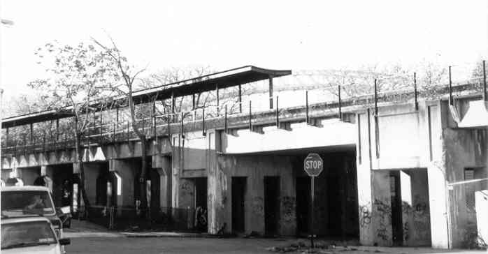 Staten Island is NYC's most auto-dependent borough. Direct rail transit links to Brooklyn, Manhattan or New Jersey simply do not exist. Not surprisingly, Staten Islanders are more than twice as likely to own and use cars as residents of the other four boroughs. This car dependence, with its accompanying problems of chronic traffic congestion, pollution, casualties from car crashes and the paving over of the Island's once-beautiful natural habitat, didn't happen by chance. It began with a public policy decision in the 1920s to halt construction of a Staten Island-Brooklyn rail tunnel that would have provided regional freight and passenger service.
Not long after that, the island's streetcar network that connected its villages was dismantled, and highway building agencies took over as chief planners. The Port Authority slapped up three highway toll bridges -- the Goethals and the Outerbridge in 1928, and the Bayonne in 1931 -- to New Jersey, which were huge money losers until 1964, when Robert Moses opened up the island to much greater numbers of cars by having his Triborough Bridge and Tunnel Authority complete the motor-vehicles-only Verrazano Narrows Bridge to Brooklyn. City and state agencies built still more expressways to feed these bridges, their tollbooths and their highway budgets, thus creating self-fulfilling perpetual traffic generators, the exact opposite of urban planning. Today, of course, traffic congestion, suburban sprawl and car chaos are worse than ever. In 1998, the Port Authority even pushed hard for but thankfully failed to win approval for a second highway-only bridge next to the Goethals.
Light Rail: Back to the Future!
Staten Island is NYC's most auto-dependent borough. Direct rail transit links to Brooklyn, Manhattan or New Jersey simply do not exist. Not surprisingly, Staten Islanders are more than twice as likely to own and use cars as residents of the other four boroughs. This car dependence, with its accompanying problems of chronic traffic congestion, pollution, casualties from car crashes and the paving over of the Island's once-beautiful natural habitat, didn't happen by chance. It began with a public policy decision in the 1920s to halt construction of a Staten Island-Brooklyn rail tunnel that would have provided regional freight and passenger service.
Not long after that, the island's streetcar network that connected its villages was dismantled, and highway building agencies took over as chief planners. The Port Authority slapped up three highway toll bridges -- the Goethals and the Outerbridge in 1928, and the Bayonne in 1931 -- to New Jersey, which were huge money losers until 1964, when Robert Moses opened up the island to much greater numbers of cars by having his Triborough Bridge and Tunnel Authority complete the motor-vehicles-only Verrazano Narrows Bridge to Brooklyn. City and state agencies built still more expressways to feed these bridges, their tollbooths and their highway budgets, thus creating self-fulfilling perpetual traffic generators, the exact opposite of urban planning. Today, of course, traffic congestion, suburban sprawl and car chaos are worse than ever. In 1998, the Port Authority even pushed hard for but thankfully failed to win approval for a second highway-only bridge next to the Goethals.
Light Rail: Back to the Future!What would it be like to live on Staten Island today if in the Twenties, it had modernized and expanded its streetcar network to connect with neighboring Newark, Bayonne and Brooklyn? Let's go back to the future! Modern light rail transit (LRT) would give Staten Islanders a brand new choice for travel. Lightweight LRT cars could easily cross the Verrazano Bridge, defying Moses' plan to "design-out" rail transit. In New Jersey, NJ Transit is making detailed plans for a Newark-Elizabeth light rail line in Union County. Officials hope to extend this line to a shopping complex near Newark Bay, only a stone's throw from Staten Island. Connecting these segments into a coherent interstate light rail system would reduce pressure on roads everywhere and would free tens of thousands of motorists from the tyranny of the car. But the Port Authority, counting on the steady flow (and increase) of toll revenues from Staten Islanders using the bridges, seems dumbstruck regarding rail options. Openly defying federal clean air laws, the Port's plans for a second Goethals Bridge would have more than doubled capacity for single-occupant auto travel to and from Staten Island. In lockstep with the Port Authority, NY State is lining up millions of dollars to add new lanes to the Staten Island Expressway and to expand Brooklyn's Gowanus Expressway during its projected multi-billion dollar rebuild to attract and accommodate a new tidal wave of cars (and toll collections for their coffers). But a new flood of cars pounding over newly widened highways cannot be matched anywhere else in the region with new city street capacity. Existing local and arterial streets, already choked with traffic, cannot absorb any more. The cost of traveling rises, the economy stagnates and everyone's quality of life -- and health -- continues to freefall. New thinking and new action is required. We present these ideas in the spirit of raising the level of public debate about the North Shore rail line. The success of the plan, a complex one, to replace the Gowanus Expressway with a light rail line to Staten Island hinges on support of communities all along the route. It is hoped that this proposal will be of use to the new Governor of NY this January, and to Governor Jon Corzine of NJ as they consider transit investments and reshape transport strategies to match fiscal realities. Radials and Loops Most of the region's rail transit links are "radial," feeding people to and from the Manhattan business district, by far the region's largest job concentration. Staten Island's single remaining rail line -- the fourteen-mile Tottenville-St. George line -- connects to the ferry for a slow, but pleasant (in good weather) ride to lower Manhattan. (S.I.'s premium fare express buses run non-stop to Manhattan as well). But most of the region's automobile travel is not Manhattan-bound. To compete for this market, rail transit must include a loop that would augment the existing radial system. Fortunately, our region has many abandoned or lightly used rail rights-of-way in place that can be tied together relatively easily and inexpensively into a circumferential rail line. In 1992, the Environmental Defense Fund [now called Environmental Defense] proposed just that: a complete 75-mile inner loop, ideal for light rail, which permits street running to bypass any gaps in the right of way, and which can cross existing bridges with lightweight cars. Shortcut to Manhattan Light rail over the Verrazano Bridge would connect Staten Island with Manhattan, via Brooklyn's Third Avenue and a converted Battery Tunnel. This radial light rail line, proposed in the July/Aug 1994 issue of New York Streetcar News, would use the median of an at-grade Gowanus Expressway in Brooklyn and one tube (two tracks) of the Brooklyn-Battery tunnel to a lower Manhattan terminal. This proposal, which involves tearing down the crumbling elevated highway rather than spending half a billion dollars or more to rebuild it, has been gaining ground with community groups in Sunset Park, Red Hook and Carroll Gardens and with the Staten Island Advance and City Councilman John Fusco. Their concerns forced the State at one point to consider the tear-down option. The Verrazano LRT could terminate at the Grasmere Station of the S.I. rapid transit or, even better, share tracks with the SIRT north and south, eliminating the transfer at Grasmere. Such joint operation of light rail and heavy rapid transit is already working in Cleveland, Ohio, where Shaker Heights LRT cars operate on rapid transit tracks for access to the downtown terminal. New low floor platforms could be added at existing high floor SIRT stations to accommodate modern low floor trolleys. Alternatively, LRT cars with both high and low floors, similar to the San Francisco Muni LRT, could be used on this line. One last option would be to convert the entire SIRT to low floor LRT operation, and the existing equipment, nearly identical to NYC's subway cars, reassigned to other lines. After leaving Grasmere Station, the LRT would stop at the St. George ferry terminal, and continue west along the restored North Shore line. This new transit service would be a tremendous boon for the communities and neighborhoods along the North Shore. These older districts are more densely settled than the rest of Staten Island, especially the more recent sprawled out McMansion suburbs south of the Staten Island Expressway. Heading west from the ferry, the North Shore line passes under the approach to the Bayonne Bridge. A connection across this bridge, specifically built to carry rail, could be made to the Hudson-Bergen Waterfront LRT line, giving Staten Islanders a new alternative to reaching Manhattan, via Hoboken. This new option alone would be a huge leap forward for Staten Islanders! Heading westward, the five-mile St. George-Arlington portion of this line is a fully grade-separated double track roadbed with seven intermediate stations, built in the 1930s. Structures would be renovated, track upgraded and new low platform stations constructed, with provision for wheelchair passengers. Crossing the Arthur Kill The island's only rail link to the rest of the country is the presently unused single-track vertical lift bridge across the Arthur Kill to New Jersey. This drawbridge, part of the City's recent purchase of the North Shore line, would be used for both freight trains and LRV's. Here's how: Marine traffic on the Arthur Kill is mostly oil and solid waste barges, which can fit under the drawbridge in lowered position. The bridge can be raised for the rare passage of larger ships. At the Staten Island end of the bridge sits the Howland Hook container ship terminal, soon to be reactivated. "Double-stack" container trains will cross the bridge to reach ship side trackage for easy transfer. At full capacity the terminal will handle one or two trains per day, boosting the local economy by restoring freight car delivery to the island's industrial plants dotting its western and northern waterfront. Rail freight will be further bolstered when the City repairs the float bridge at St. George, permitting freight cars to be floated across the harbor to the 65th St. terminal in Bay Ridge, Brooklyn. But can passenger trains mix with freight? Today, LRV's successfully co-exist with light density freight operations in San Diego and Baltimore, and several locations in Europe. This requires fail-safe signal protection and strengthened light rail car bodies, along with maintaining clearances for taller double-stack trains. Improved rail freight is vital to reduce the region's longstanding overdependence on trucks for goods movement, especially to points east of the Hudson. Near term prospects for rail freight across the Arthur Kill will still permit adequate levels of LRT service. In the longer term, if and when freight traffic grows, more tracks can be added. Next stop: Downtown Elizabeth At the west end of the drawbridge, only 1,500 feet of double track is needed to reach the nearby Conrail freight line for a straight two-mile run to Elizabethport and the proposed eastward extension of the Newark-Elizabeth LRT. With only modest upgrading, Conrail's once-busy double track freight line can handle both light density freight and frequent LRT service. LRV's would continue west to Elizabeth, and eventually southwest to Cranford, Plainfield and Summit (if Union County's LRT plan is achieved), and north to Newark Airport and Newark. Future articles to be posted here, that originally appeared in the New York Streetcar News, will complete the series on the LRT loop, via a route through northern NJ and across the George Washington Bridge to the Bronx. Paying for the New Link Current plans (as of 2003) are to rebuild the decking of the aging Goethals Bridge, which would cost around $250 million. Highway interests are still pushing for a second Goethals which would cost even more, with substantial additional costs in motor vehicular related ills. Instead, the two Governors must insist that the Port Authority finance the North Shore rail link as a way to cut traffic on the existing Goethals while it is being rebuilt. The Arlington-St. George transit link (see map) would cost around $60 million. The short track connection needed in Elizabeth, and modifying and upgrading rail freight trackage, might require another $60 million. A new cross-island rail link, coordinated with local buses rerouted to act as feeders, would be a very attractive alternative — the carrot — to car commuters stuck in the chronic traffic jams around and on the Goethals. Along with the carrot comes the stick: congestion pricing for bridge tolls with rates based on vehicle occupancy, to assure high quality highway service for essential car and truck traffic while avoiding the heavy negative impacts of a new span. The Goethals Bridge is functionally obsolete and even unsafe, with room for only four narrow (by today’s standards) 10 foot lanes. By diverting motorists to the new LRT line and by shifting a lot of heavy truck freight to rail, traffic conditions will become less hazardous. With an adequate transit system available, more rigorous enforcement measures would be acceptable to the public, weeding out motorists with poor driving skills. A movable barrier, similar to one now used on the Tappan Zee Bridge, could divide the bridge into three full width lanes, two in the peak direction, though some reverse peak congestion might occur. A better long term solution would be a combined shipping/surface transport plan for the Arthur Kill to reduce the use of this waterway by large ocean-going tankers and to restore its water quality and marine life. A lower clearance (and less expensive) fixed bridge for trains might then be sufficient. Return to the Auto-Free NY home page.
© Copyright 2004, 2018. All rights reserved. Auto-Free New York.
|